Level 4 Weather Warning: Hail and Storms Hit SA
Level 4 Severe Weather Warning Issued for South Africa as Hail, Lightning and Heavy Storms Threaten Several Provinces
The South African Weather Service (SAWS) has issued a Yellow Level 4 severe thunderstorm warning for parts of South Africa, with heavy rainfall, hail, severe lightning and strong winds expected to affect several provinces on Friday, 6 November 2026.
The highest warnings apply to Gauteng, northern KwaZulu-Natal and the south-western Highveld of Mpumalanga, where storms could cause localised flooding, damage to infrastructure and dangerous travelling conditions.
Additional Yellow Level 2 warnings have been issued for parts of the Free State, North West, Limpopo, Mpumalanga and KwaZulu-Natal.
The warnings are expected to remain in effect until midnight on Friday.
Residents have been urged to take precautions, particularly in flood-prone communities and areas vulnerable to lightning, hail and strong winds.
Gauteng Under Level 4 Warning as Johannesburg and Pretoria Face Severe Storms
Gauteng is among the areas facing the highest level of severe thunderstorm warnings issued for Friday.
Johannesburg, Pretoria and Ekurhuleni could experience heavy downpours, hail and intense lightning activity.
The weather service has warned of possible large quantities of small hail over populated areas.
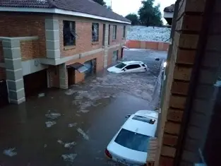
Heavy rainfall could overwhelm drainage systems and cause localised flooding in low-lying areas.
Roads and bridges may become dangerous, while falling trees and storm damage could disrupt electricity supplies and telecommunications.
Temperatures are expected to remain high before thunderstorms develop.
Johannesburg is forecast to reach approximately 31°C, while Pretoria could reach 33°C.
Both cities have been forecast to experience a 60% chance of showers and thunderstorms.
These rainfall probabilities do not indicate that every neighbourhood will experience a severe storm.
Ekurhuleni Emergency Services Placed on High Alert
The City of Ekurhuleni has placed its Disaster and Emergency Management Services on high alert.
Emergency response teams, including aquatic rescue and vehicle rescue units, are on standby to respond to weather-related incidents.
Municipal emergency services spokesperson William Ntladi warned that heavy rainfall could result in flooding, damaged infrastructure and blocked roads.
Informal settlements and low-lying residential areas may be particularly vulnerable.
Strong winds could also uproot trees and damage buildings, vehicles and electricity infrastructure.
Residents have been urged not to attempt to cross flooded roads, rivers or bridges.
The municipality has advised people facing life-threatening emergencies to contact its emergency services on 011 458 0911.
Northern KwaZulu-Natal Faces Heavy Rain, Hail and Lightning
The northern parts of KwaZulu-Natal are also under a Yellow Level 4 warning.
Areas including Richards Bay and Mtubatuba have been identified among those at risk of severe thunderstorms.
The forecast includes heavy downpours, hail and dangerous lightning.
Localised flooding could affect roads, settlements and infrastructure.
Central KwaZulu-Natal, including areas around Durban and Pietermaritzburg, is covered by a lower Yellow Level 2 warning.
The province is also expected to experience hot and humid conditions, particularly in the north-east.
SAWS has warned that the humidity could create extremely uncomfortable conditions.
Residents should remain alert to rapidly changing weather, especially during the afternoon and evening.
Mpumalanga Highveld Also at Risk
The south-western Highveld of Mpumalanga is included in the Yellow Level 4 warning.
Severe thunderstorms may affect parts of the province’s high-altitude interior, while other Highveld areas are under a Yellow Level 2 warning.
Heavy rainfall, hail and lightning could create dangerous conditions for motorists and communities.
eMalahleni and Ermelo are among the towns forecast to experience showers and thunderstorms.
Temperatures are expected to reach approximately 31°C in eMalahleni and 28°C in Ermelo.
The Lowveld and northern escarpment are expected to experience different weather conditions, with much of the region remaining comparatively dry.
The warning therefore does not apply equally to every part of Mpumalanga.
Level 2 Warnings Issued for North West, Free State and Limpopo
The weather service has also issued Yellow Level 2 severe thunderstorm warnings for several inland areas.
In North West, the eastern parts of the province face a risk of heavy downpours, hail and localised flooding.
Rustenburg and Potchefstroom are among the towns where thunderstorms are expected.
The eastern Free State is also at risk, with Bethlehem forecast to experience showers and thunderstorms.
In Limpopo, parts of the Western Bushveld are covered by the Level 2 warning.
These storms may cause localised flooding and damage to vulnerable infrastructure.
Although Level 2 warnings generally indicate a lower expected impact than Level 4 warnings, they should still be taken seriously.
What Does a Yellow Level 4 Weather Warning Mean?
The South African Weather Service uses an impact-based warning system to communicate the potential consequences of hazardous weather.
The system considers both the likelihood of a weather event and the severity of its possible impacts.
A Yellow Level 4 warning indicates a potentially significant impact, even where the likelihood is assessed as relatively low.
It does not mean that every location within the warning area will experience destructive weather.
Possible consequences include flooding, damage to homes and infrastructure, traffic disruption and interruptions to essential services.
The warning is intended to help residents, businesses and emergency services prepare before hazardous conditions develop.
Heavy Rainfall Could Cause Flash Flooding
Flash flooding is one of the main risks associated with severe thunderstorms.
Intense rainfall can cause water levels to rise rapidly in streets, streams and drainage channels.
Urban areas may experience flooding when stormwater infrastructure cannot accommodate the volume of rain.
Low-lying roads and bridges are particularly dangerous because water can conceal damaged surfaces or strong currents.
Drivers should avoid attempting to cross flooded roads, even when the water appears shallow.
Pedestrians should also avoid crossing swollen streams or drainage channels.
If flooding threatens a home or business, residents should move to higher ground and follow instructions from emergency services.
Lightning and Hail Pose Additional Dangers
Severe thunderstorms can produce dangerous lightning strikes.
People working outdoors, participating in sports or travelling through open areas may be particularly exposed.
Residents should seek shelter inside substantial buildings when thunderstorms approach.
Standing beneath isolated trees, remaining in open fields or using exposed metal equipment can increase the risk of lightning injury.
Hail may also damage vehicles, roofs, windows and agricultural crops.
Where possible, motorists should move vehicles under suitable cover before severe storms arrive.
People should avoid unnecessary outdoor activity during intense lightning and hail.
Strong Winds Could Disrupt Electricity and Communications
Thunderstorms may be accompanied by strong, damaging winds.
These conditions can uproot trees, damage roofs and bring down power lines.
Electricity and telecommunications infrastructure may be affected in some communities.
Residents should stay away from fallen electrical cables and report damaged infrastructure to the appropriate authorities.
Businesses and households may also consider charging essential communication devices and securing loose outdoor objects before storms develop.
The warning indicates a risk of disruption rather than confirmation that outages have already occurred.
Extremely High Fire Danger in Other Parts of South Africa
While eastern parts of the country face thunderstorms, SAWS has also warned of extremely high fire danger in several regions.
Affected areas include parts of the Northern Cape, Free State and North West, most of Limpopo, northern Gauteng and parts of Mpumalanga.
Hot, dry and windy conditions can increase the likelihood of fires spreading rapidly.
Residents in affected areas should avoid activities that could ignite vegetation or other combustible materials.
This demonstrates that South Africa can experience very different weather hazards simultaneously.
Weekend Weather Outlook
The South African Weather Service expects unsettled weather to continue across parts of the eastern regions during the weekend of 7 and 8 November.
KwaZulu-Natal could experience widespread showers and thunderstorms.
Other eastern areas may see isolated to scattered showers and storms, with cooler conditions developing in some places.
Elsewhere, much of the country is expected to remain fine and warm to hot.
The weekend outlook may change, and residents should consult updated forecasts before travelling or planning outdoor activities.
Safety Precautions During Severe Thunderstorms
Residents in affected areas are encouraged to follow these precautions:
- Stay indoors when severe thunderstorms and lightning develop.
- Avoid crossing flooded roads, bridges and swollen rivers.
- Move vehicles under suitable shelter where possible to reduce hail damage.
- Secure loose outdoor furniture and other objects that could be blown away.
- Keep children and pets away from floodwater and exposed electrical infrastructure.
- Avoid standing under isolated trees during lightning storms.
- Follow official weather alerts and instructions from local emergency services.
- Report fallen power lines, blocked roads and dangerous flooding to the relevant authorities.
Motorists should reduce speed during heavy rainfall and allow additional travelling time.
Where visibility becomes dangerously poor, drivers should stop in a safe location away from flood-prone areas.
Conclusion
The Yellow Level 4 severe thunderstorm warning places parts of Gauteng, northern KwaZulu-Natal and the south-western Mpumalanga Highveld at risk of heavy rainfall, hail, lightning and flooding on Friday, 6 November 2026.
Other parts of the country are covered by Level 2 warnings, while extremely high fire danger conditions have been forecast for several inland regions.
Emergency services in Ekurhuleni have already placed rescue teams on standby as authorities prepare for possible storm-related incidents.
Residents are encouraged to remain alert, avoid unnecessary risks and monitor official weather updates.